
Hacienda San Diego Cutz
Hacienda San Diego Cutz | |
|---|---|
Private Event Venue | |
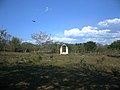
.JPG) Entrance of the Hacienda San Diego Cutz under the name of Hacienda Arango[1] (possibly after the recordings of the telenovela Abismo de pasión) | |
 Hacienda San Diego Cutz  Hacienda San Diego Cutz | |
| Coordinates: 21°05′44″N 89°32′42″W / 21.0955191°N 89.5448942°W | |
| Country | Mexico |
| Mexican States | Yucatán |
| Municipalities | Conkal Municipality |
| Founded | 1874 |
| Population (2010)[2] | |
| • Total | 0 |
| Time zone | UTC−6 (CST) |
| • Summer (DST) | UTC−5 (CDT) |
| Postal code | 97345[3] |
| Area code | 999[4] |
Hacienda San Diego Cutz is a private event venue in the Conkal Municipality in Yucatán, Mexico.
Toponym[edit]
The name (San Diego Cutz) refers to Didacus of Alcalá and Cutz means Wild turkey (Meleagris gallopavo) in the Mayan language.
Historical importance[edit]
It had its splendor during the time of the henequen boom and issued hacienda tokens which, due to their design, are of interest to numismatists. These records certify the farm as property of J. Ancona and sons in 1874.[5]
Historical facts[edit]
- In 1995 it changes its name from San José Kuché to San Diego Cutz, to distinguish it from the hacienda of similar name in Mérida Municipality.
In popular culture[edit]
This hacienda is best known for her role in the Televisa telenovela Abismo de pasión. where is the official residence of the Arango family and where Damían Arango (David Zepeda) and Alfonsina Mondragón (Blanca Guerra) live.[1]
Demographics[edit]
According to the 2005 INEGI census, the population of the town was 0 inhabitants.[2]
| Year | 1910 | 1921 | 1930 | 1940 | 1950 | 1960 | 1970 | 1980 | 1990 | 1995 | 2000 | 2005 |
|---|---|---|---|---|---|---|---|---|---|---|---|---|
| Population | 233 | 94 | 124 | 5 | 43 | 47 | 2 | 8 | 0 | ? | ? | 0 |
Gallery[edit]
-
 View of a water well in San Diego Cutz
 -
![Main garden of the Hacienda[1]](//upload.wikimedia.org/wikipedia/commons/thumb/1/18/San_Diego_Cutz%2C_Yucat%C3%A1n_%2803%29.JPG/120px-San_Diego_Cutz%2C_Yucat%C3%A1n_%2803%29.JPG) Main garden of the Hacienda[1]
Main garden of the Hacienda[1] -
 Other rooms
 -
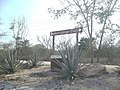 Sign announcing the location of the hacienda
.JPG)
![Main garden of the Hacienda[1]](/wiki/File:San_Diego_Cutz,_Yucat%C3%A1n_(03).JPG)
.JPG)
.JPG)
References[edit]
- ^ a b c "¿Dónde se grabó la Novela de Abismo de Pasión?" (in Spanish). PorEsto!.
- ^ a b Instituto Nacional de Estadística y Geografía (2010). "Principales resultados por localidad 2010 (ITER)".
- ^ Servicio Postal Mexicano. "Consulta Códigos Postales - 97345". Retrieved 2 August 2011.
- ^ Instituto Nacional de Estadística y Geografía (2010). "Principales resultados por localidad 2010 (ITER)".
- ^ Enciclopedia Yucatanense, Edición Oficial del Gobierno de Yucatán, páginas 900-902, México, D.F., 1977.